Community Wildfire Protection Plan
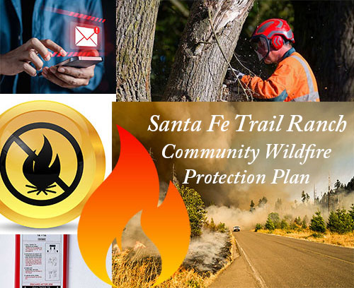
SFTR - Community
Wildfire Protection Plan
Santa Fe Trail Ranch
Community Wildfire Protection Plan
2024 Update
The Santa Fe Trail Ranch (SFTR) Community Wildfire Protection Plan was originally prepared by Land Stewardship Associates, LLC at the request of the Santa Fe Trail Ranch Property Owners Association in 2006. Significant work has been accomplished on Santa Fe Trail Ranch each year since the creation of the original CWPP in the form of fuel reduction both collectively and by individual property owners. In 2015, it was determined by the community that another release of the SFTR CWPP would be valuable showing all the activities that have been done, re-prioritizing goals for the future and assessing all structures for survivability if a wildland fire were to occur. Jim Webb from Land Stewardship Associates was contracted to do structure assessments and provide guidance. The Forest Health and Wildfire Mitigation Committee of SFTR prepared the updated document and presented the 2016 version of the SFTR CWPP to all the collaborating parties in Las Animas County for concurrence and signatures.
In 2022, it was again determined by the committee that another release of the SFTR CWPP would be valuable, updating and correcting the 2016 version. The first section I, “Community Identification & Description” has not significantly changed. Section II, “Community Assessment” has been updated to reflect significant changes that have occurred since 2016. The most obvious change is the abandonment of the concept of individual structure evaluations and placing that responsibility on the property owner. Reflecting input from the CSFS, Section III, “Community Mitigation Plan” has also been updated. Many “links” have been added to the document that are indicated by underlined text. These links lead to websites and documents that are also referenced in Appendix L. References to the SFTR Community Wildfire Protection Plan can be found in the Las Animas County Hazard Mitigation Plan.
The updated “Fire Control Features” map is an ESRI ArcGIS geodatabase, including spatial data which can be readily shared with local and federal agencies. The geodatabase includes Spatial data layers including mappable locations for hydrants, structures, evacuation routes, fire control features, fuel breaks, roads and parcel boundaries that can be searched for data combinations and locations, plus be loaded and used on a mobile GPS-enable device through ArcGIS Online.
The PDF version of the map is a ANSI-E Sheet (34 x 44-inch) high resolution map which can be printed and laminated at a print shop. A hard copy map is useful when emergency management does not have the resources to utilize a mobile device or is working within areas lacking network connectivity.
| SFTR CWPP | 2 | 4/23/2024 |
| SFTR CWPP | 3 | 4/23/2024 |
Table of Contents
|
I. COMMUNITY IDENTIFICATION & DESCRIPTION |
6 |
|
II. COMMUNITY ASSESSMENT |
8 |
|
Fuel Hazards Based on Rate of Spread & Resistance to Control |
8 |
|
Fuel Models |
9 |
|
Table 1: Fuel Models Found in Santa Fe Trail Ranch |
9 |
|
Chart 1: Santa Fe Trail Ranch Fuel Model Coverage |
10 |
|
Risk of Ignition & Wildfire Occurrence |
10 |
|
Table 2: Santa Fe Trail Ranch Fire Behavior Predictions |
10 |
|
Chart 2: Flame Lengths on SFTR |
11 |
|
Colorado Forest Atlas fire behavior maps |
11 |
|
Community Values at Risk & Hazard Assessment |
12 |
|
Access |
12 |
|
Risk |
12 |
|
Evacuation |
13 |
|
Emergency Evacuation and Emergency Response |
13 |
|
Local Preparedness & Protection Capability |
14 |
|
Water Supply |
15 |
|
Grazing |
15 |
|
III. COMMUNITY MITIGATION PLAN |
16 |
|
Defensible Space |
16 |
|
A Fire Adapted Community |
17 |
|
Home Ignition Zone |
18 |
|
Chart 3: Slope Impact on Survivable Space |
19 |
|
Chart 4: Slope Impact on Defensible Space |
19 |
|
Education & Information |
20 |
|
Fuel Hazard Reduction |
20 |
|
Mitigation work completed on Santa Fe Trail Ranch to 2023 |
22 |
|
Table 3: SFTR Potential Shaded Fuel Breaks |
23 |
|
Proposed (recommended) SFTR Shaded Fuel Breaks Map |
24 |
|
Fuel break Maintenance |
25 |
|
Treatment Costs |
25 |
|
Wildfire Suppression Infrastructure |
26 |
|
Turnarounds |
26 |
|
Availability of water for firefighting |
26 |
|
Fire Control Features Map |
26 |
|
Fire Control Features Map |
27 |
|
Table 4: CWPP Action Plan |
28 |
| SFTR CWPP | 4 | 4/23/2024 |
Appendices
|
A – Hydrant characteristics |
29 |
|
B – Sample Specifications for Turnarounds |
30 & 31 |
|
C – Fuel Hazard Reduction Guidelines |
32 |
| D – Defensible Space Maintenance & Gambel Oak | 33 & 34 |
|
E – Definition of Terms |
35 & 36 |
|
F – Structure Triage |
37 |
|
G – SFTR Surface Fuels map |
38 |
| H – SFTR Rates of Spread map | 39 |
|
I – SFTR Flame Lengths map |
40 |
|
J – Colorado Forest Atlas fire behavior maps |
41 & 42 & 43 & 44 |
|
K – Addresses on the Santa Fe Trail Ranch |
45 & 46 & 47 |
|
L – References, Website Links, Documents and Maps |
48 & 49 & 50 |
| SFTR CWPP | 5 | 4/23/2024 |
I. COMMUNITY IDENTIFICATION & DESCRIPTION
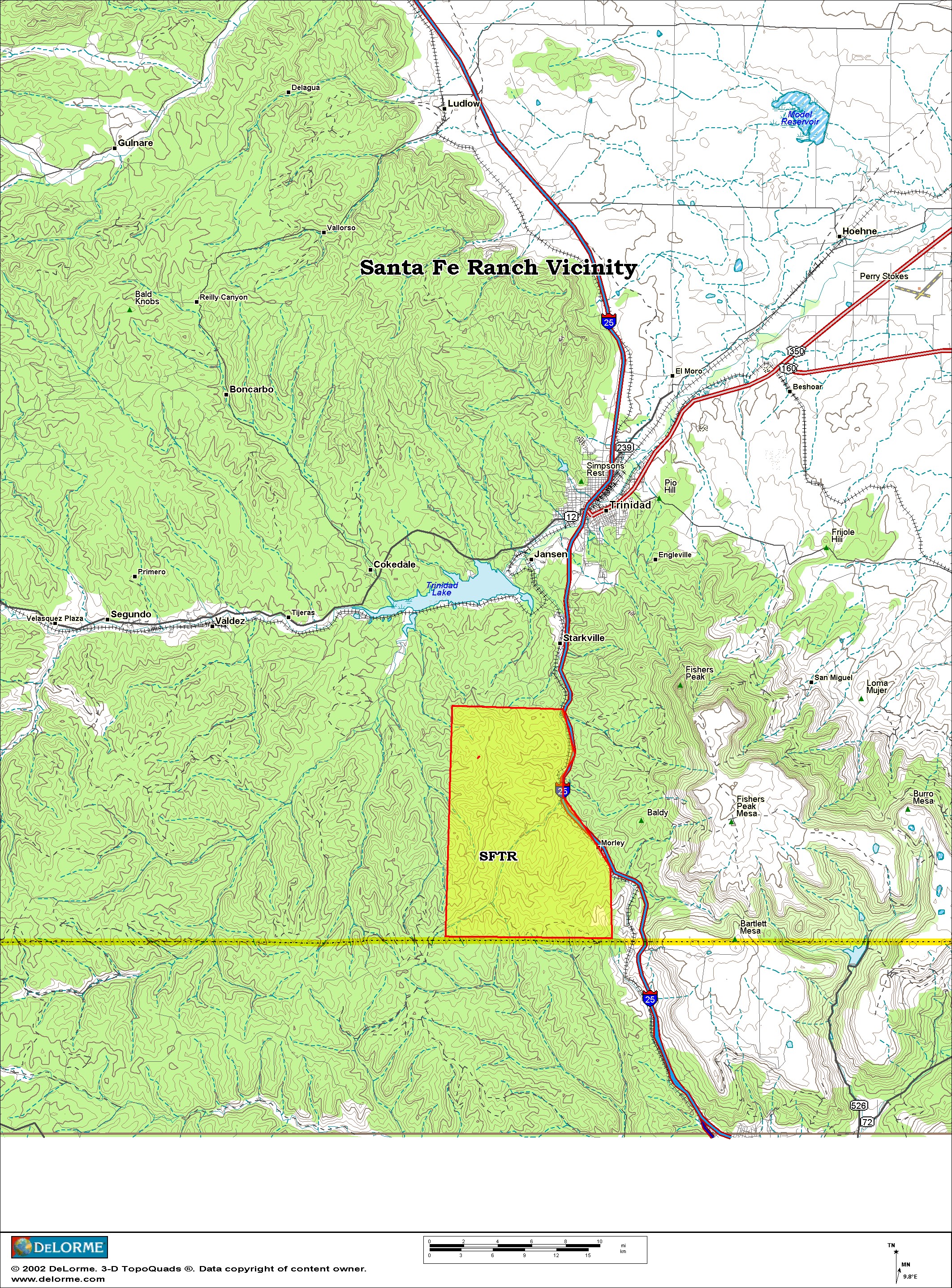
The Santa Fe Trail Ranch (SFTR) community area is in Las Animas County, south of Trinidad Colorado, near the Colorado/New Mexico state line. It covers approximately 16,800 acres and ranges in elevation from 6,500 to 8,100 feet. Interstate Highway 25 provides access to the ranch. See the attached vicinity map for a comprehensive understanding of the ranch location.
SFTR contains four hundred and fifty-four (454), 35 acre parcels, approximately 250 of which have structures on them. Approximately six to eight new homes are being built each year. Eighty-two (82) miles of reasonably good dirt and gravel roads provide year-round access.
There is a very active property owner’s association (POA) guiding many of the activities on the Ranch. Defensible space activities are wide spread as well as collaborated fuel reduction fuel breaks. A significant fuel break entirely created by property owners on their own land is called the G2T fuel break. This fuel break starts at Timber Park Drive at lot F-53 and ends at Fawn Court at Lot E-8 crossing seven lots.
Previous fires in the area have created a vegetative tapestry of pinyon, juniper, ponderosa pine and Douglas fir in the over-story with a rich shrub under-story composed of Gambel oak, New Mexican locust, mountain mahogany, skunk-bush and chokecherry. This vegetative blanket lays on a highly-dissected series of ridges, draws and canyons. Slopes range from ten to fifty percent with an average approximating thirty percent.
Large wildfires are not unusual in Las Animas county. The Morley fire burned 300 acres on the Ranch in 1978 and was followed by Morley fires 2 & 3 in 1979 & 1980. The fire season of 2002 provided a serious wake up call to local residents living in forested/wooded environs. That year saw the Crazy French fire (300 acres) and the Trinidad Complex Fire (32,896 acres). In 2011, the Shell Complex (14,651 acres), Track Fire (27,792 acres) and James John (6,800 acres) fires were all in the Santa Fe Trail Ranch vicinity. The East Peak fire in 2013 burned 13,572 acres and the Stateline fire burned 10,330 acres in 2018. The Spring Creek Fire, also in 2018, was a wildfire near Fort Garland and La Veta, Colorado in Costilla and Huerfano counties in southern Colorado. The fire burned a total of 108,045 acres and was the third-largest wildfire in Colorado history. These and other fires have increased Ranch residence awareness of the hazards of living in a wildland setting.
Initial attack for all wildland and structure fires on Santa Fe Trail Ranch is provided by the Fisher’s Peak Fire Protection District, Volunteer Fire Department.
Since the initial creation of the SFTR Community Wildfire Protection Plan in 2006 numerous meetings and input has been taken from the Colorado State Forest Service and incorporated into the SFTR CWPP.
| SFTR CWPP | 6 | 4/23/2024 |
| SFTR CWPP | 7 | 4/23/2024 |
II. COMMUNITY ASSESSMENT
The overall risk to the community from wildland fire was assessed as HIGH in 2006 and remains so. See the “Rate of Spread” and “Flame Lengths” maps in Appendix H and I. Since 2006 considerable efforts on fuel breaks on the South and West Boundaries have been completed as well as internal fuel breaks and widespread mitigation by individual lot owners. The fire risk is still high at this time. This section will discuss the factors considered and contributing to the overall rating.
Fuel Hazards
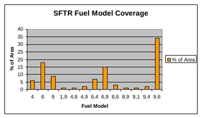
Dense stands of conifer (ponderosa pine, pinyon pine, Douglas-fir and juniper) and brush (Gambel oak, New Mexican locust, mountain mahogany, and chokecherry) cover the Ranch. Fuel ladders are abundant and will lift ground fire into the crowns of the over-story. There are only a few small meadows scattered throughout the Ranch. Fire Behavior Fuel Models 1, 4, 6, 8, & 9 (Anderson 1982) are all found in various associations with one another. All but fuel models 8 & 9, have high rates of spread under relatively mild weather conditions. Table 1, Fuel Models Found in Santa Fe Trail Ranch provides a brief description of these five key fuel models. Appendix G is a map of the various types and locations of “Surface Fuels” found on the SFTR.
All stands adjacent to structures with crown closures greater than forty percent are problematic. Continuous surface and crown fuel arrangement, both horizontal and vertical, render this area susceptible to torching, crown fire, and ignition by wind born embers, even under moderate weather conditions. As the table below and Chart 1 show, fully ninety percent (90%) of the ranch is rated as high fire hazard.
Local topography further aggravates fire behavior and control. Slopes range from ten to fifty percent with most hillsides ranging from twenty to thirty percent.
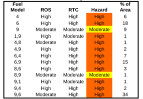
NOTE: ROS = Rate of Spread & RTC = Resistance to Control
| SFTR CWPP | 8 | 4/23/2024 |
Fuel Models
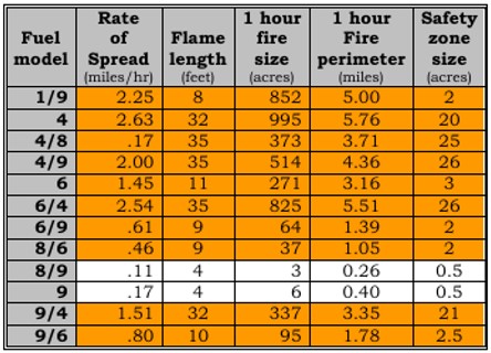
Fuel models are a means of describing a wide variety of combustible conditions found in a wildland environment. Thirteen (13) standardized fuel models are used in wildfire behavior prediction. Fuel size class, fuel loading in tons/acre, fuel bed depth, and fuel continuity across a landscape are all factors that are considered when assigning a fuel model to a specific tract of land. Since it is unrealistic to expect thirteen (13) descriptions to represent the wide continuum of fuel beds found in the wild, fuel models are often combined by the percentage of an area they cover. Table 1: Fuel Models found in Santa Fe Trail Ranch concisely describes fuel models in the development.
Table 1: Fuel Models Found in Santa Fe Trail Ranch (from the 2016 CWPP)
|
Fuel Model |
Description |
|
1 |
Grasslands generally less than 1 foot deep |
|
4 |
Shrub stands > 6 feet tall |
|
6 |
Shrub stands < 4 feet tall |
|
8 |
Closed canopy stands with short-needle conifers or hardwoods that have leafed out support fire in the compact litter layer. |
|
9 |
Closed stands of long needled pine or hardwood stand with freshly fallen leaves |
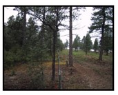
Here are a few representative photos of fuel models found on SFTR
 |
 |
 |
 |
| Fuel Model 1 | Fuel Model 2 | Fuel Model 3 | Fuel Model 4 |
| SFTR CWPP | 9 | 4/23/2024 |
Chart 1: Fuel Model Coverage on Santa Fe Trail Ranch (2006 assessment)
Risk of Ignition and Wildfire Occurrence
The robust vegetative mosaic found on the ranch is living testimony to fires role in ecosystem dynamics in the area. Most contemporary fires are lightning caused but human caused fires are expected to increase as more homes are built on the ranch. Surprisingly there are very few railroad fires along the tracks across Raton Pass. Fires are normally prevalent along steep railroad grades. The Burlington Northern & Santa Fe Railroad Company is doing a good job of wildfire prevention by keeping their right of way mowed and free of flammable vegetation.
The Morley fire of 1978, burned three hundred (300) acres on the Ranch. Normally two to three small fires occur on the Ranch each year. 2002 was a very active wildfire year. Three major blazes burned over forty thousand acres in the SFTR vicinity.
Low fuel moisture and low relative humidity are common in the area, as are periods of high winds. When dry and windy conditions coincide, the stage is set for large, troublesome wildfires.
Fires originating in or near the community are the most immediate concern, but fires starting well beyond the boundaries of the planning area can have profound effects upon the Ranch. Rapid rates of spread and long distance spotting (starting of new fire by wind blown embers) are the norms for fires in the vicinity. The Spring fire of 2002 started in New Mexico and made an eleven-mile run toward Colorado in just one afternoon. Table 2 below provides insight into potential fire behavior on a bad day at Santa Fe Trail Ranch.
| SFTR CWPP | 10 | 4/23/2024 |
Table 2: Santa Fe Trail Ranch Fire Behavior Prediction (from the 2016 CWPP)
Note: Shaded zones are well beyond hand crews & engine suppression threshold
Fire behavior predictions are based on the average weather conditions for the month of June 2002 recorded at the Bosque (a.k.a. Cuchara) Remote Automated Weather Station (RAWS) #56203. This RAWS sits at 8,174 feet elevation and is reasonably close to SFTR.
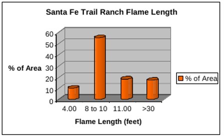
Chart 2: Flame Lengths on Santa Fe Trail Ranch (from the 2016 CWPP
The most current fire behavior maps located in the Colorado Forest Atlas produced by the Colorado State Forest Service may be found in Appendix J.
| SFTR CWPP | 11 | 4/23/2024 |
Community Values at Risk & Hazard Assessment Values:
Two hundred fourty three (243) of the four hundred fifty-four (454) lots on the Ranch have structures identified as blue trianges on the Fire Control Features map. Structures range from substantial permanent residences to metal sheds. Approximately six to eight (6-8) new homes are being built each year. Approximately sixty percent (60%) of the structures are occupied year long.
Ranch owners place a high premium on their natural surroundings and the visual quality of the landscape. Vast expanses of heavily burned, charred forest are objectionable whether structures burn or not. If the view is seriously eroded much of the intrinsic value of the home will also be lost.
A large, intense fire will also compromise watershed values and cause sediment and turbidity issues along Raton Creek and Trinidad Lake. Most of the ponds on the ranch which are impounded by earthen dams would be filled with sediment, compromising wildlife and livestock watering opportunities. That sediment will also clog road culverts leading to road erosion and repair costs.
Access: Eighty-two (82) miles of gravel and dirt roads provide reasonably good access to the Ranch. All of the intersections are signed. Driveways have addresses posted. The addressing system, established in August of 2006 is described in Appendix K.
Road grades often approach ten percent (10%) on the main arterial roads in the community. Driveways can be as much as fifteen percent (15%). All dead-end roads have “No Outlet” signs at the junction with the main road. Most cul-de-sacs at the end of the roads are inadequate for large structure fire equipment.
Risk: Three kinds of risk are associated with wildland fire. The first concern is the risk to property owners trying to evacuate under less than optimal conditions. Second is the risk to firefighters attempting to protect property. Third is the risk to the property from wildfire. The concept of hardened structures and defensible space addresses both the second and third facets of risk under one umbrella.
Home hardening involves modifying your home to reduce the likelihood of structural ignition. Buildings cannot be made fireproof, but the chance of your home surviving wildfires increases when you reduce structural ignitability through home hardening in tandem with the creation and maintenance of defensible space. Roofs, vents, windows, exterior siding, decks, and gutters are particularly vulnerable to wildfires. Research on home survival during wildfires demonstrates that enclosed eaves and vent screens can reduce the penetration of wind-born embers into structures. Multi pane windows have greater resistance to radiant heat. Windows often fail before a home ignites, providing a direct path for flames and airborne embers to enter a home. It is important to replace wood or shingle roofs with noncombustible materials such as composition, metal, or tile. Ignition-resistant or noncombustible siding and decking further reduce the risk of home ignition, particularly when homes also have a 5-foot noncombustible border of dirt, stone, or gravel. Non-wood siding and decking are often more durable and require less routine maintenance.
| SFTR CWPP | 12 | 4/23/2024 |
Defensible space is an area around the structures where fuels and vegetation are treated, cleared or reduced to slow the spread of wildfire towards the structure and lower the intensity of the fire as it passes the developed area. It also reduces the chances of structure fire moving from the building to surrounding vegetation. Defensible space provides room for firefighters to do their jobs. A house is likely to withstand a wildfire if vegetation is managed to reduce a fire's intensity. Structure design and construction also influence its survivability when a wildfire passes through the neighborhood. Removing flammable materials such as fire wood, lumber and gasoline from the decks and base of structures will pay big dividends when the ember storm hits the home. The 2015 structure assessment indicated that 44% of SFTR structures have a high likelihood of survival in a wildfire occurrence with no human intervention.
The updated “Fire Control Features” map identifies lot boundaries, roads, structure locations, firefighting resources, mitigated areas and gated undeveloped exit points. The “Fire Control Features” map is a high resolution ESRI geodatabase including spatial data that can be used on a mobile device through ArcGIS Online. The 34 x 44-inch PDF map can be downloaded with the link provided on page 27.
Evacuation: The SFTR Preparedness Committee maintains the “Community Preparedness Handbook”, which is available to all property owners on the SFTR website. This handbook discusses the SFTR Emergency Plans including Emergency Reporting, Evacuation Situations and Evacuation Procedures. A copy of the “Community Preparedness Handbook” can be downloaded from the SFTR website.
Also available on the SFTR website is a link to the Las Animas County CodeRED website and the Reverse-911 signup page. All property owners should register their phone numbers on this site to receive emergency notifications.
Emergency Evacuation and Emergency Response: The biggest safety issue on SFTR is the ability to respond to emergencies. One of the major concerns is the existence of only one entrance/exit to the ranch. In the event of an emergency fire evacuation, should the one exit become blocked or routes to it become blocked or otherwise compromised, there is currently no alternative which may leave property owners trapped in the path of an oncoming fire front. Firefighters, Colorado State Forest Service, National Firewise USA as well as many other organizations recognize the need for at least two primary exits from a Wildland Urban Interface property such as SFTR. Unfortunately, due to the geographical location of the ranch, there is currently no realistically available second primary entrance/exit. There are several exit routes across neighboring properties that could conceivably be used as an escape route in extreme conditions. These routes would involve trespass across neighbor properties and would only be considered as a life saving resort. Consideration of these routes should be negotiated with the appropriate property owners involved.
Owners should plan in advance of an emergency and familiarize themselves with likely routes to all possible exits with attention to possible choke-points or obstacles which may require modifications mid-route. These changes in routes and plans should be evaluated in advance, since making these decisions in the midst of an emergency may lead to inappropriate decisions or regrettable choices.
| SFTR CWPP | 13 | 4/23/2024 |
Evacuation information and education can be offered by the Preparedness Committee, but owners should plan and practice on their own. The Committee should include a method to communicate rapidly and effectively as far as practical to all members of SFTR the imminent need for an emergency evacuation such as reverse 911 or other methods. Residents who may not be able to manage a timely evacuation on their own should arrange for assistance in the event of emergency. Owners’ evacuation plans should be rehearsed annually to allow for whatever revisions and improvements may be deemed necessary after a review of each trial. The Preparedness Handbook which is maintained by the Preparedness Committee should provide guidance to the community and reflect upon lessons learned during evacuation practices.
Emergency responses on SFTR can vary wildly from a single medical or police vehicle to one residence to a multiple unit fire response to a wide area of the ranch. SFTR desires to provide a safe workplace for first responders. They as well as our residents need more than one exit to avoid being trapped on the ranch. It is recommended that our first responders be provided with both a set of digital and printed maps of SFTR in a format big enough to be easily read.
Local Preparedness and Protection Capability
Fisher’s Peak Fire Protection District (FPFPD), Volunteer Fire Department has a cadre of 12 firefighters, 4 of which are SFTR residents. If firefighters respond from Station 1 (in Starkville), response times to SFTR are 35-45 minutes. if firefighters respond from Station 3 (on the SFTR), response times are usually 20 -25 minutes. Response times also depend on how many firefighters are available. FPFPD has mutual aid agreements with the Hoehne, Stonewall, Boncarbo, Spanish Peaks, Trinidad, and Pinon Canyon Districts that add additional resources. Response times from these departments are at least an hour out with availability dependent upon workload at the time of request. Dispatching is done by county emergency response dispatchers.
- Equipment at Station 1 in Starkville
FP Engine 1 Standard Type 1 Structure Protection Engine 1,000 Gal. Water
FP Engine 2 Standard Type 1 Structure Protection Engine 500 Gal. Water
FP Rescue 1 Specialty, 300-gal water, 20-gal foam, hydraulic rescue tools.
FP Brush 3 Standard NWCG Type 6 Engine 500 Gal. Water
FP Brush 4 Standard NWCG Type 6 Engine 220 Gal. Water
FP Tender 1 Standard NWCG Type 1 Tactical Tender 1,400 Gal. Water
FP SRU Specialty apparatus. Mobile Command Center. Drone command.
Drone 1&2 Two drones with infra-red cameras for smoke spotting and fire location.
Equipment at Station 3 on Santa Fe Trail Ranch (Lot D-73)
FP Engine 5 Standard NWCG Type 4 engine with inventory. 900 Gal. Water.
FP Brush 2 Standard NWCG Type 6 Engine inventory. 300 Gal. water.
| SFTR CWPP | 14 | 4/23/2024 |
Water Supply: The SFTR Metro District owns and operates and maintains the community water distribution system which consists of three 110,000 gallon water storage tanks and six pump stations. Although most property owners are connected to this system, some residents haul water to fill cisterns instead of paying the tap fees. Each developed lot is expected to have at least 1,500 gallons of water storage on site for fire protection. Most of these tanks are underground. Some of the residents now connected to the Metro District water system either do not have a cistern or are by-passing their cisterns and should be encouraged to keep them full and available at all times.
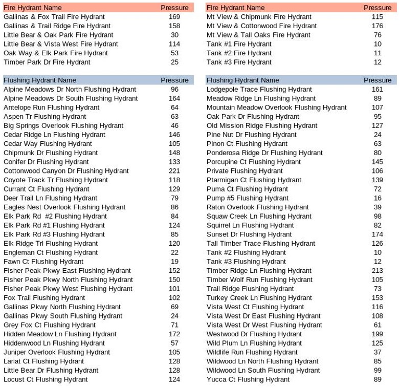
There are 12 fire hydrants on the Ranch that have pressures, with the exception of the fire hydrants at the tanks, between 25 and 173 pounds per square inch. Water pressures at the 64 flushing hydrants at the ends of most cul-de-sacs vary from 16 to 213 pounds per square inch, depending upon elevation of the hydrant relative to that of the storage tank or upstream pressure relief valve. A water system model prediction of fire hydrant and flushing hydrant pressures is found in Appendix A. Hydrant characteristics, pumping stations, fire hydrants, flushing hydrants and storage tank locations are shown on the “Fire Control Features Map” on page 27.
In the event of an emergency, the Metro District will control the system to maximize the water supply for firefighting needs. Residents should also maximize their cistern supply and minimize their usage understanding that some waterlines may be temporarily interrupted or closed. Defensible space standards should be implemented at all critical infrastructure locations to ensure function and reduce potential damage. Visit the SFTR Metro District website for more information.
Although there are several small ponds on the ranch, only the pond at the upper end of Gallinas canyon (between Lots J9 & J10) is adjacent to a road and may be counted on for wildfire suppression purposes.
Grazing: SFTR is a working ranch with cattle grazing lease. The grazing cattle help to keep the grasses and other fine fuels from accumulating in the open areas of the ranch. Without the cattle to keep these fine fuels under control a significant effort will be required to periodically keep the grasses and other fine fuels mowed throughout the growing season. We currently have no methods to manage grazing to optimize wildfire mitigation benefits. More grazing information is available on the Grazing committee page of the SFTR website.
| SFTR CWPP | 15 | 4/23/2024 |
III. COMMUNITY MITIGATION PLAN
Defensible Space:
A hardened structure and an effective, well maintained defensible space, is the landowners’ most reliable means of providing wildfire protection for their structures. This is especially true on the Santa Fe Trail Ranch. Complex terrain, heavy fuels, and landownership patterns on the Ranch make landscape level fuel modification very difficult. The 2006 and 2016 plans identified fuel breaks along strategic ridges and roads, some of which have now been completed. This new plan suggests shaded fuel breaks that should be completed. The key to individual structure survival is Hardened Structures (ember resistant), Defensible Space and regular maintenance of both.
See the Firewise USA section of the National Fire Protection Association website for more details. Also see the CSFS publications, the Home Ignition Guide and the Home Ignition Zone (HIZ) checklists.
During periods of high to extreme fire danger a wildfire will rapidly exceed the suppression capability of the local fire suppression forces. Table 2. Santa Fe Trail Ranch Fire Behavior Prediction, displays the difficult position firefighters will face on a dry, windy day. Hand crews are effective when flame lengths are less than four feet. On a bad day only ten percent of the Ranch is expected to have fire of this intensity. As shown on Chart 2, the rest of the area will experience flame lengths from nine to thirty-five feet. The size of a fire within the first hour is also expected to grow beyond local initial attack capability over eighty-five percent (85%) of the ranch.
Homeowners should not expect much protection intervention if/when a large fire burns on or through the Ranch. The harsh realities of triage and coordinating attack with mutual aid forces will consume local fire forces for several hours. In 2015 professional forester Jim Webb evaluated the existing homes on SFTR for survivability without human intervention if a catastrophic fire occurred. Individual structures are no longer evaluated, the homeowner is expected to follow the Firewise USA, National Fire Protection Association and Forest Service guidelines referenced above. A hardened structure and an effective defensible space is the key to structures surviving on their own. Do it now and keep it maintained.
In many cases, sizable effort has been spent developing defensible space around quality homes perched on the edge of a steep slope with heavy vegetation below the structure. Unfortunately, the trajectory of the flames will intersect the structure, exposing it to direct contact with the fire. During the past site visits for triage, several landowners acknowledged the paradox they have created with the location of their home. Land owners should be encouraged to set new homes back from the edge of steep, brushy slopes. Also see Chart 3 and Chart 4 and Appendix F: Structure Triage for additional information.
| SFTR CWPP | 16 | 4/23/2024 |
Fire Adapted Communities:
Communities in wildfire prone areas are learning what it takes to be fully prepared for wildland fire. A fire adapted community incorporates people, buildings, businesses, infrastructure, cultural resources, and natural areas into the effort to prepare for the effects of wildland fire. Community leaders and residents accept responsibility for living in an area with wildfire hazards. They have the knowledge and skills and have adopted tools and behaviors to prepare in advance for their community’s resilience in a wildfire prone environment. For more information see the USFS publications Managing the Land > Wildland Fire and When your community is on the fire line.
A Fire Adapted Community
• Acknowledges and understands its wildfire risk
• Recognizes that it is in or near a fire prone ecosystem
• Has leaders and citizens with knowledge, skills, willingness and realistic expectations to properly prepare for and deal with wildland fire
• Communicates clearly with citizens about wildfire risks and specific methods for preparedness
• Has adequate local fire suppression training, equipment, and capacity to meet realistic community protections needs
• Creates and uses a Community Wildfire Protection Plan (CWPP)
• Reduces levels of flammable vegetation on lands near and inside the community
• Has local building, planning, zoning and fire prevention policies and codes that require ignition resistant buildings, building materials, and landscapes
• Has buildings and landscapes that are designed, constructed, retrofitted, and maintained in a manner that is resistant to ignition
• Creates safety features such as buffers between fuels and neighborhoods, designated evacuation routes, and internal neighborhood safety zones
• Makes sure fire adapted community features, activities, and behaviors are maintained over time
• Has leaders and residents who coordinate, plan and collaborate to leverage their resources to reduce wildfire risk while increasing community resiliency
Home Ignition Zone
Although wildfire can threaten a building in three different ways (burning embers, direct flame contact, and radiant heat), ember exposure is the most significant cause of ignition. For example, windblown embers (firebrands) can directly ignite easily ignited materials such as a wood shake roof, lawn chairs, firewood piles, mulch, pine needles, or debris that has accumulated in gutters, roof valleys, or around dormers. Other combustible building components, such as siding or a deck, would be vulnerable to the flames or radiant heat from these more easily ignited materials. Gable ends and open eave vents are also vulnerable to the entry of embers, which can then ignite combustible items in attic spaces. Because embers can travel a long distance when carried up by convection currents, a wildfire is still a threat even if it is miles away.
Research confirms that certain key characteristics determine which buildings burn and which buildings survive. Keeping property free of debris, repaired, screened, and properly sealed, and maintaining fire resistant landscaping reduces the likelihood of building ignition.
| SFTR CWPP | 17 | 4/23/2024 |
Everyday preparedness actions are important, such as creating a fuel free (mulch free) zone within five feet of the building’s foundation, moving firewood piles and propane tanks away from buildings, keeping roofs clean, keeping combustible landscape plants away from buildings, and disposing of landscape trimmings. These preparatory actions must be regularly performed before a wildfire occurs to improve the survivability of people and property.
A home with its immediate surroundings (about 100-200 feet from the structure) is the home ignition zone.
Recent research into the cause for loss of homes during wildfires indicates that home ignitability, rather than wildland fuels, is the principal cause of home losses during wildland/urban interface fires. Key items are flammable roofing materials (e.g. cedar shingles) and the presence of burnable vegetation (e.g. ornamental trees, shrubs, firewood piles, and pine needle accumulation immediately adjacent to homes (Cohen, 1999).
The home ignition zone includes a home and its immediate surroundings within 100 to 200 feet of the structure. Fuel conditions within this zone, to a large degree, will determine whether a home will survive a wildfire. High intensity fire behavior beyond the home ignition zone does not transfer enough energy directly from its flames to ignite a wooden structure. The fuels surrounding a home within the home ignition zone principally determine the potential for directly igniting the home. Firebrands lofted from extreme wildfires must directly ignite on a structure to be an effective ignition source. If firebrand ignitions occur in the fuels surrounding a home, then those fuels determine the home’s ignition potential. Thus, regardless of how far firebrands travel, a home’s exterior materials and design and fuels in the home ignition zone determine its ignition potential from firebrands.
The primary and ultimate responsibility for home wildfire protection lies with private homeowners, not public land management agencies (or taxpayers). It is critical that special attention be given to reducing fuels in the home ignition zone around structures to improve their chances of surviving a wildfire. This includes insuring that there are no combustible materials like concentrations of pine needles, dry grass, hay or straw, firewood, deck furniture, household trash, flammable materials such as gasoline, diesel or paint thinners, paper boxes, and fabrics near the structure or in the home ignition zone for firebrands to land on. In the past few years research has found that a significant number of homes destroyed in wildfires burned as the result of the presence of combustible materials within the home ignition zone. Some homes ignited as much as 8 hours after the fire front passed. Reducing places for embers to penetrate the home such as open windows and vents also significantly improves structure survivability.
| SFTR CWPP | 18 | 4/23/2024 |
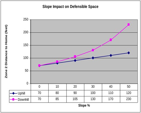
Chart 3: Slope Impact on Survivable Space (from the 2016 CWPP)
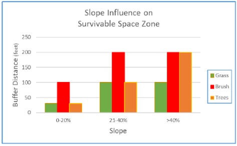
This Chart 4 indicates how far thinning needs to be done above and below a structure based on the slope it is on or adjacent to. It is also a good source to determine how far back from a slope to set a new structure.
Chart 4: Slope Impact on Defensible Space (from the 2016 CWPP)
| SFTR CWPP | 19 | 4/23/2024 |
Education and Information:
The SFTR Forest Health and Wildfire Mitigation Committee (FHWMC) was formed in 2004. The Mission of the Committee is to actively promote mitigation of fire hazards and advance ecologically sound forest management practices by heightening awareness, fostering education, and mobilizing property owners to support goals and objectives which will promote a safer and healthier forest environment. The SFTR Forest Health and Wildfire Mitigation Committee organizes community-wide mitigation and educational projects; promotes a healthy and resilient forest; renews and implements the CWPP, applies for grants/funds for mitigation/education/forest health projects, and establishes partnerships with community neighbors, other POA committees, local government and emergency services.
The SFTR has had their Firewise recognition renewed every year since 2006. More information is on the FHWM committee page and the Firewise-Info page of the SFTR website.
Fuel Hazard Reduction:
Since the initial CWPP in 2006, the Colorado State Forest Service and Santa Fe Trail Ranch have worked cooperatively with Vermejo Park Ranch and the Wootton Ranch to develop a shaded fuel break on these two ranches along the southern and southwestern borders of the SFTR. A continuous fuelbreak that extends from the port of entry on I-25 to the SW corner of SFTR and continues north for about 1.5 miles along the western boundary was completed in 2010. Maintenance of a portion of the Vermejo Park and Wootton Ranch fuel break was completed in December of 2023 with a FRWRM “SFTR SW Fuelbreak Project” grant award to maintain this treatment area.
Since 2005 numerous grants have been applied for on both the State and Federal level. SFTR has received some of these grants and has meticulously administered them on fuel reduction efforts. Most of these grants have been match grants where residents have come up with the matching dollars or completed in-kind work for the match. These efforts have resulted in fuel reduction for fuel breaks and significant mitigation around many of the homes on SFTR.
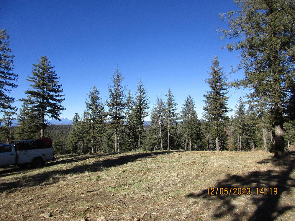
 This photo shows the fence-line contrast along the boundary between SFTR (left side of photo) and Vermejo Park Ranch (right side of photo) on the south west corner of the Ranch. Removal of the under-story growths of Gamble Oak and New Mexico Locust and extensive tree thinning begins to break up the continuous ground fuels.
Many roads on SFTR run along ridges and provide marginal opportunities to make a stand against an aggressive fast moving fire. Their utility as fire control features can be improved substantially by thinning both sides of the road. Road rights of ways (ROW) extend thirty feet each side of the center line.
| SFTR CWPP | 20 | 4/23/2024 |
A sixty foot wide break is a start towards an adequate break in fuel continuity but is not sufficient to provide the kind of safety needed in the heavy fuels found on the Ranch. The SFTR POA also has a fifteen foot easement on each side of the ROW allowing additional mitigation to increase the fuel break width to ninety feet. It is also necessary to remove trees along the roadway for several reasons. Since our electrical service lines are installed along the sides of the roads in the ROW easement, we need to keep the trees cleared away from the power lines to avoid contact with the power lines which can result in arcing which can start a fire. We should also be clearing trees which are in danger of taking down the power lines if they are blown down in a windstorm or fire. These blow-down trees can also fall across the road and prevent safe passage along the roadways which could be a major hazard during a fire evacuation of the SFTR residents. Cutting of trees close to the power lines should only be done by the San Isabel Electric Association with the proper equipment and safety training. Homeowners should contact SIEA if they have a concern with trees and power lines. Clearing tall trees along the roadway also allows more sunlight onto the road surface to help melt snow and dry mud on the road.
Once the treatment immediately adjacent to the roadway is completed further tree thinning is necessary to attain a 60% opening (view of the sky between trees) within the canopy to create a three hundred foot wide corridor. The tree thinning to this extent is designed to disrupt the continuous layer of fuels within the treetops thus forcing a crown (treetop) fire to the ground where it can be effectively attacked with hand crews or with water or fire retardant drops from the air. It is critical that these fuel breaks be continuous. Thinning to get a three hundred (300) foot wide break requires negotiations with many landowners. Without widespread individual landowner cooperation, creating effective fuel breaks is not feasible. See Appendix C: Fuel Hazard Reduction Guidelines for additional information and the CSFS Fuel break Guidelines for Forested Subdivisions & Communities.
Since the initial CWPP in 2006, fuel breaks have been completed on Gallinas Parkway and along the SFTR borders with Vermejo Park Ranch and the Wootton Ranch. Other fuel breaks have been started on Cottonwood Canyon (50% complete), Mountain View (75% complete) and Tall Oaks (70% completed). Continued work on these existing fuel breaks should be prioritized before moving on to the other “Proposed Fuel Breaks“ illustrated on the map on page 24.
The Mitigation map on page 22 illustrates the progress toward fuel break creation on the SFTR over the past 20 years. The fuel reduction that has been done improves fire control opportunities along strategic ridges and begins to break up the hazardous fuel continuity on the Ranch. Property owners should contribute by allowing additional thinning beyond the road corridor to improve fire control efforts at those locations. SFTR has a good start but there is much work yet to do. As fuel breaks are completed throughout SFTR they begin to form the basis for splitting the ranch into Potential Operational Delineations (PODS) as recommended by Colorado State Forest Service (CSFS). PODS are areas defined by potential fire control features such as roads and ridgetops that can act as the basis of where fire control can be initiated. Future PODS delineations will be determined by FPDs, CSFS, and USFS partners. This map should be updated frequently and the current version found on the SFTR website.
Table 3: Santa Fe Trail Ranch Proposed Fuel breaks on page 23, lists the CSFS recommended fuel breaks and their characteristics that should ultimately be created on the SFTR. Recommended fuel treatments are discussed in Appendix C.
| SFTR CWPP | 21 | 4/23/2024 |
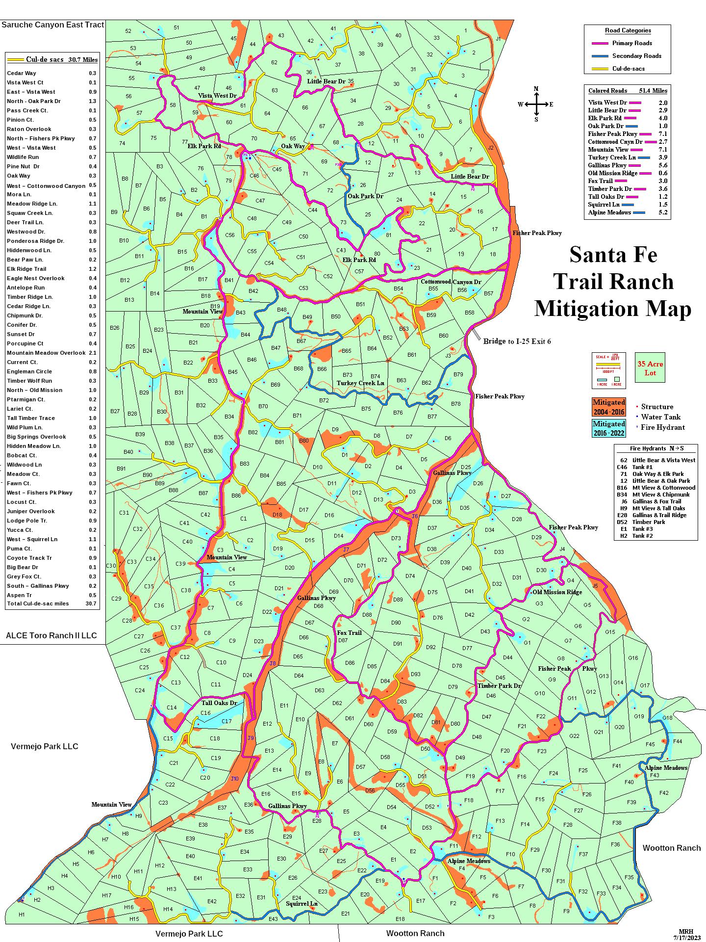
Mitigation work completed on Santa Fe Trail Ranch (click for PDF)
Pre 2016 in orange – Post 2016 in blue
| SFTR CWPP | 22 | 4/23/2024 |
Table 3: Santa Fe Trail Ranch Proposed (recommended by the CSFS) Fuel breaks
(an aid in prioritization)
|
Fuel Break Name |
Fuel Break Status |
Ridge Line |
Control Location |
Evacuation Route |
Characteristics |
Rationale |
Acreage @ 300 ft |
|
Vermejo Park Ranch |
Maintenance |
Yes |
Yes |
No |
Colorado |
SW neighbor |
445 |
|
Vermejo Park Ranch |
Maintenance |
Yes |
Yes |
No |
New Mexico |
S neighbor |
445 |
|
Wootton Ranch |
Maintenance |
Yes |
Yes |
No |
New Mexico |
SE neighbor |
445 |
|
Porcupine / Engleman |
Maintenance |
Yes |
Yes |
No |
Cross Country |
Low cost |
15 |
|
Mountain View |
80% complete |
Yes |
Yes |
Connector |
Alternative route |
Low cost |
186.5 |
|
Tall Oaks Dr |
50% complete |
No |
No |
Connector |
North Hillside |
High cost |
32.7 |
|
Fishers Peak (Alpine-Morley) |
0% complete |
Yes |
Yes |
Safe Zone Access |
Escape route |
Medium cost |
32 |
|
Gallinas South |
0% complete |
Yes |
Yes |
Water tank Access |
Escape route |
Medium cost |
69.1 |
|
Fox Trail |
20% complete |
Yes |
Yes |
Connector |
East Hillside |
Medium cost |
102.2 |
|
Gallinas Conservancy |
Maintenance |
No |
Yes |
Bridge exit access |
Canyon wide |
Low cost |
162 |
|
Fisher Peak / Alpine Meadows |
10% complete |
Yes |
Yes |
Connector |
Escape route |
Medium cost |
74.6 |
|
Timber Park / Old Mission |
0% complete |
Yes |
Yes |
Safe Zone Access |
West Hillside |
High cost |
99.8 |
|
Gallinas to Timber Park |
Maintenance |
No |
No |
No |
Cross Country |
Low cost |
36 |
|
Cottonwood Canyon Dr |
50% complete |
No |
No |
Bridge exit access |
Canyon narrow |
Medium cost |
101.8 |
|
Turkey Creek |
0% complete |
Yes |
Yes |
Connector |
Alternative route |
Medium cost |
49.6 |
|
Little Bear |
0% complete |
No |
No |
Bridge exit access |
South Hillside |
Low cost |
101.9 |
|
Elk / Oak Park |
0% complete |
No |
No |
Connector |
South Hillside |
High cost |
83.6 |
|
Vista West Dr |
0% complete |
No |
Yes |
Connector |
North Hillside |
Medium cost |
125.6 |
| SFTR CWPP | 23 | 4/23/2024 |
Proposed SFTR Shaded Fuel Break Map(click for image) (recommended by the CSFS)

| SFTR CWPP | 24 | 4/23/2024 |
Maintenance: Gambel Oak and New Mexican Locust are abundant under-story species on the Ranch. They also sprout vigorously after they are cut. Keeping them under control following thinning will be a task. Two methods are effective to keep them in check. Mowing is effective but has to be done on an annual basis. Herbicide treatment is also effective but may be objectionable to some landowners. See Appendix D: Defensible Space Maintenance & Gambel Oak for a further discussion on herbicide control of Gambel oak.
It will be wise to have a maintenance option in mind prior to fuel break construction. The Santa Fe Trail Ranch BOD has an annual allocation for some Maintenance mowing on the Gallinas Parkway Fuel Break. Property owners are expected to maintain the roadway frontage of the shaded fuel breaks along their property.
Treatment Costs: Treatment costs for defensible space and shaded fuel break work are highly variable depending on the amount of thinning and slash disposal to be done and the relative care involved in doing the work. Hand crews working next to structures and chipping the slash will cost from $1,000 to $2,000 per acre. Mechanical thinning with a hydro-ax type machine will normally cost from $400 to $700 per acre depending on tree density, slope and rockiness. The SFTR strives to ensure that projects and costs per acre are in alignment with the CSFS Forest Action Plan. Appendix 7 of that plan discusses “Average Costs by Forest Cover Type” in the Colorado State Forest Service area.
| SFTR CWPP | 25 | 4/23/2024 |
Wildfire Suppression Infrastructure:
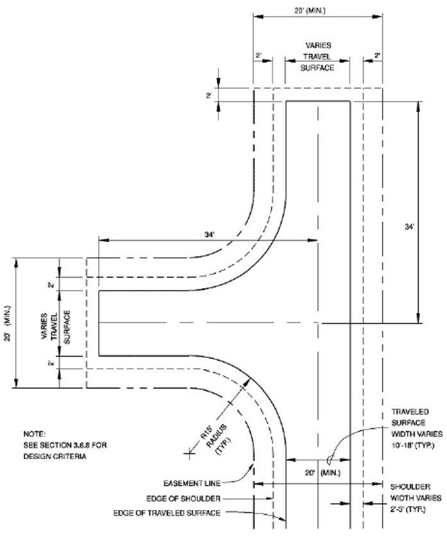
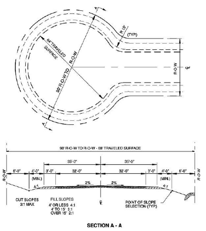
Turnarounds: Space is lacking, to turn around fire equipment at the end of most dead-end roads. In fact, in many cases the terminus is even tight for a full sized pickup truck. Flushing hydrants are usually located right at the end of the road and fire trucks will be shuttling water from these locations. See Appendix B, Sample Specifications for Turnarounds for additional details.
Accommodations for turning vehicles around near the end of the road are critical for fire suppression purposes. In some cases, there is little room to construct turnarounds at the end of the roads so locating a turnaround as near the end as possible is the only option. The most feasible turnarounds for narrow dead end roads is to create a pistol drive where a larger vehicle could drive down and have a short drive to back in and then complete the turn. Thus, the large radius required for a cul-de-sac (120 feet) would not be needed. This should be a high priority item. The SFTR POA should allocate funds to accomplish this over the next few years as part of the road maintenance plan.
Availability of water for firefighting: The three 110,000 gallon water tanks in the SFTR water system are the primary source of water on the ranch, with private cisterns on individual properties as a secondary supply. We need a written agreement of how this water is accessed and how it is utilized in a fire emergency. Private cisterns need to be accessible for use by firefighters with either appropriate piping and fittings to allow direct coupling of firefighting equipment or more feasibly, provide access with a three inch port to allow direct drafting through the suction hose of a fire pump. All water tanks should be equipped with a high volume gate valve.
Fire Control Features Map: The map developed for this Community Wildfire Protection Plan provides invaluable information for wildland fire fighting. While the firefighters from Station 3 may know the Ranch like the back of their hand, reinforcements and mutual aid folks will struggle with the road layout and fire suppression opportunities. Likewise, knowledge of the water system operation is confined to volunteer property owners serving the SFTR Metropolitan District. Communications can be enhanced by providing this quality map that shows these important features.
It should be noted that the “Structures” icons are those with established addresses, that additional structures may be present at that site and many unaddressed structures are present on the ranch but are not indicated. The “Locked Gate” icon indicates locations of gates that do not represent currently viable exits or evacuation routes. Areas indicated as “Mitigation Work Through 2016” as well as more recent areas indicated on the Mitigation Map on page 22 represent areas that should, but may not be, currently well maintained.
The SFTR Forest Health and Wildfire Protection Committee will provide a large laminated version of this map to dispatchers, first responders, the Sheriff's department and Colorado State Forest Service. They will also store this map at the SFTR MOC to distribute during the inevitable emergency. Below is the JPG version the 2023 “Fire Control Features” map with a link to the PDF version.
| SFTR CWPP | 26 | 4/23/2024 |
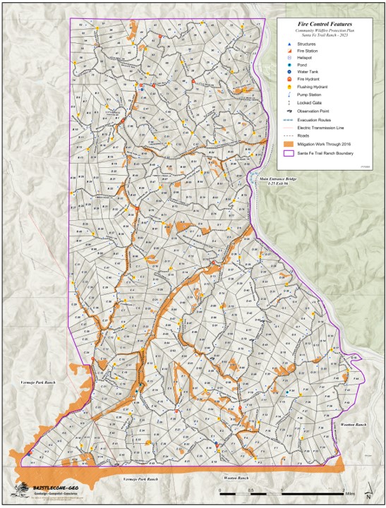
Table 4: CWPP Action Plan
|
Implementation Item |
Responsibility |
Status |
|
Implement Universal Street Addressing System |
FHWMC |
Completed 9-2007 |
|
Install high volume gate valves on all water tanks |
Metro District |
Hydrants installed 7-2016 |
|
Defensible Space Around all Structures |
Property Owners |
Ongoing |
|
Mitigate right-of-way on all roads |
FHWMC |
Ongoing |
|
Laminated “Fire Control Features” map |
FHWMC |
Completed in 2023 |
|
VPR, Wootton – Maintenance |
FHWMC |
Planned for 2023 - 2027 |
|
Maintenance of existing fuel breaks |
FHWMC |
Ongoing |
|
Negotiate & Document second ranch entrance/exit |
POA BOD |
To be determined |
|
Negotiate & Document alternate evacuation routes |
POA BOD |
To be determined |
|
Negotiate & Document rights to MD firefighting water |
POA/Metro |
To be determined |
|
Construct Turnarounds on dead end roads |
Road Comm |
Planned for 2023 – 2027 |
|
Update Community Preparedness Handbook |
Preparedness Comm |
Planned for 2024 |
|
Evacuation plan revision |
Preparedness Comm |
Yearly |
|
Evacuation Simulation |
Preparedness Comm |
Yearly |
| SFTR CWPP | 28 | 4/23/2024 |
Appendix A: Hydrant Characteristics:
| SFTR CWPP | 29 | 4/23/2024 |
Appendix B: Sample Specifications for Turnarounds:
Hammer Head Turnaround:
| SFTR CWPP | 30 | 4/23/2024 |
Local Cul-de-Sac:
| SFTR CWPP | 31 | 4/23/2024 |
APPENDIX C – Fuel Hazard Reduction Guidelines
MINIMUM TREE SPACING – RULE OF THUMB
Strive to reduce crown density to 40% or less.
Ponderosa Pine/Douglas Fir: Convert stem diameter from inches to feet and add 7 more feet.
Example: A Ponderosa Pine 8” in diameter at DBH will have a spacing of 8 feet
plus 7 feet for a total of 15 feet to the next tree.
Tree spacing does not necessarily need to be even. In fact, the fuel treatment area will look more natural if the spacing varies and small clearings are intermingled with small groups of trees. The important focus should be on breaking up fuel continuity – both horizontally and vertically. If trees are very tall in relationship to their diameters, implement the thinning work over a long enough time to allow the standing trees to develop their wind firmness and resistance to snow bend. Thinning when trees are small helps reduce/prevent these vulnerabilities. Thinning in patches and designing the thinning to minimize wind effect can be done depending on location. All of these can be used but can best be accomplished with the assistance of an experienced forester.
An important part of fuel hazard reduction is removal of the ladder fuels; particularly when adequate thinning cannot be accomplished. Therefore, the following is important to do within a timber canopy.
- Prune trees to 6 or 10 feet above the ground, depending on slope, leaving at least 1/3 live tree crown
- Remove tree reproduction from under the canopies of remaining trees
- Remove sagebrush, oak or any other flammable brush from under the canopies of remaining trees.
- Reduce the size and height of remaining clumps of brush
- Remove all dead forest debris within defensible space and Fuel break areas.
- Reduce concentrations of dead forest debris within other areas
- Thin to stimulate growth and improve residual tree health. Remove trees recently killed by mountain pine beetle* or other disturbances
- Reduce numbers of trees recently killed by mountain pine beetle* or other disturbances within defensible space and fuel break areas. Only 1 to 3 dead trees per acre are needed for wildlife habitat purposes.
*Note: Proper slash disposal procedures should be implemented to avoid attracting Mountain Pine or other bark beetles to the project area. There are not any slash collection or burn areas on the SFTR.
| SFTR CWPP | 32 | 4/23/2024 |
Appendix D: Defensible Space Maintenance & Gambel Oak
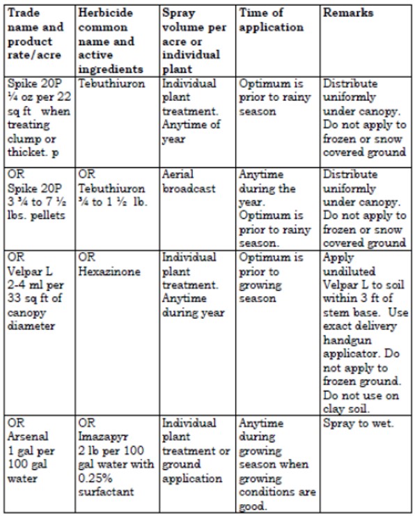
In general, residents in the Santa Fe Trails Ranch have made significant efforts to reduce fuels around their structures. They have and are continuing to thin trees, removing the lower limbs (ladder fuels) and attempting to clear the Gamble oak. The heavy woody material has been cut and stacked for firewood and the lighter material has been chipped and spread on the ground. While their efforts in reducing fuels provided by pinyon, juniper and ponderosa pine have produced a more defensible space around their homes, clearings in the Gambel oak are more troublesome. Residents we talked to complained about the aggressive sprouting that occurs after clearing the oak and the continual clearing process that is necessary to hold the oak brush in check.
Gambel oak is a native plant that is naturally associated with pinyon-juniper and ponderosa pine forests in southern Colorado. It is a deciduous shrub that is quite adaptable and easily finds a niche in the under story of these forest types as well as in relatively pure stands. It thrives on steep slopes as well as more moderate sites and on a variety of coarse and medium textured soils. Gamble oak grows in clumps that are interconnected by an extensive root system that is characterized by both shallow rhizomes and deep-feeding roots. These rhizomes send up numerous sprouts when the mature stems are removed or when injury occurs.
Eradication of Gambel oak is rare by any method and without complete kill prolific sprouting may occur from roots, rhizomes and basal stems. Treated areas usually assume a thicket-like appearance several years after the initial work (1). Numerous chemicals and combinations of chemicals have been used with limited success to control Gambel oak. Mechanical treatment, such as cutting stems and burning, are common methods of removing oak brush but it usually results in aggressive sprouting. Biological control of sprouts with repeated browsing by goats has proven to be an effective means of near elimination of oak sprouts, however, browsing by goats is not considered to be practical in all situations. Goats prefer Gambel oak leaves for forage and after several years of repeatedly defoliating the oak during the period before the oak leaves reach full growth most of the sprouts are killed (1).
On the Santa Fe Trail Ranch where Gambel oak has been cut and sprouting is occurring, the most likely treatment is one that repeatedly defoliates the oak during mid-summer. The positive effect of this repeated defoliation has been demonstrated using herbicides (1), prescribed burning (2), and browsing by goats (1). Defoliation may be accomplished by:
- mowing or chopping sprouts during mid-summer
- using goats to browse the leaves and young shoots during mid summer
- using an approved herbicide following instructions on the label kill or defoliate the sprouts during mid-summer which coincides with the time when leaf growth is reaching maximum.
Some herbicides are restricted and require an Applicators License to use. It is suggested that the Las Animas County Weed Specialist be contacted for local advice and guidance prior to using a herbicide.
New Mexico State University Cooperative Extension Service Circular 597 contains a list of herbicides for controlling Gambel oak and other undesirable brush species (3). The following table contains an excerpt from Circular 597.
| SFTR CWPP | 33 | 4/23/2024 |
Herbicides for controlling Gambel Oak
Bibliography
(1) Engle, D.M., C.D. Bonham, and L.E. Bartel. 1983. Ecological characteristics and control of Gambel oak. J. Range Manage 36(3)
(2) Harrington, M.E. 1989. Gambel oak root carbohydrates in roots of Gambel oak sprouts following herbicide treatment. J. Range Manage 42(6)
(3) Duncan, K.W., K.C. McDaniel and M.J. Renz. 2005. Chemical weed and brush control for New Mexico range-lands. New Mexico State University Cooperative Extension Service Circular 597. 18p
| SFTR CWPP | 34 | 4/23/2024 |
APPENDIX E – Definition of Terms
Community Wildfire Protection Plan- The Healthy Forest Restoration Act of 2003 establishes CWPPs as the means for communities in the wildland-urban interface to address their wildfire hazard concerns and decide how they wish to deal with them. CWPPs provide a common footing for setting priorities for the expenditure of local, state and federal funding. They are developed in a collaborative environment with all interested parties involved.
Crown Closure- An expression of how dense a forest is based on the amount of surface area covered by the crowns of trees. It is useful in many forest applications including wildfire hazard assessments. Research has shown the crown closure of forty percent or less are unlikely to support independent crown fires.
Defensible Space- Area around a structure where fuels and vegetation are treated, cleared or reduced to slow the spread of wildfire towards the structure. It also reduces the chance of a structure fire moving from the building to surrounding forest. Defensible space provides room for firefighters to do their jobs.
Flame Length- The distance from the ground to the tip of a flame is an indication of fire intensity. Fires with flame lengths less than four feet are normally thought to be controllable with hand crews. Fires with flame lengths more than four feet are usually much more difficult to control and require heavy equipment to make
much progress in suppression.
Fuel break- A linear zone of modified fuel conditions designed to reduce wildfire intensity that provides a safe place for firefighters to make a stand. They are most likely to be located on ridge-lines and evacuation routes. This zone has had the ground fuels cleaned up and the crown cover reduced to around forty percent.
Fuel Ladder- Is the fuel that creates a continuous path from the ground in to the crowns of trees or large shrubs. The more abundant fuel ladders are, the more prone a forest is to crown fire. When the limbs of the over story trees and the under-story vegetation intermix, there is a continuous fuel ladder.
Fuel Model- A means of describing various woody fuel arrangements in terms of fuel size, bulk density, fuel bed depth and tons per acre. The models are used in fire behavior prediction software.
Fuel Moisture- The amount of water in fuel per oven dry weight usually expressed in percent.
Fuel Treatment- Project to reduce or change fuel loading or type on a site that Can be accomplished by mechanical, manual, chemical, or fire use.
Helispot- A potential emergency helicopter landing site. In an emergency, landing sites, typically requiring a clear 100 foot diameter area, will be determined by the emergency personnel.
Initial Attack- An aggressive suppression action consistent with firefighter and public safety and values to be protected.
| SFTR CWPP | 35 | 4/23/2024 |
Mitigation- Those on-the-ground activities that will serve to increase the defensibility of an area; check, direct, or delay the spread of fire, and minimize threats to life, property, and resources. Mitigation actions may include mechanical and physical non-fire tasks, specific fire applications, and limited suppression actions. These actions will be used to construct fire lines, reduce excessive fuel concentrations, reduce vertical fuel, and create black lines. All mitigation requires maintenance on a regular basis to remain effective.
Preparedness- Activities that lead to a safe, efficient, and cost-effective fire management program in support of land and owners’ management objectives through appropriate planning and coordination.
Rate of Spread (ROS)- The forward rate that a fire will progress across a landscape usually expressed in chains (66ft) per hour. ROS has been converted to miles per hour in this report to be more meaningful to the intended audience.
Resistance to Control (ROS)- A means of describing how difficult it is to build and hold a fire line in a particular area. It is a relatively subjective term based on fire line production rates, slope and fuel density and usually described as high, moderate, or low.
Safety zones- A safety zone is a location where a threatened firefighter can find adequate refuge from an approaching fire. In an emergency, these sites will be established at the discretion of the fire fighting district. In a safety zone, a firefighter can survive without using a fire shelter.
Staging areas- Also called a Deployment site, are sites that will be established by the fire fighting district based upon the prevailing conditions.
Spotting- One method by which wildfires spread by means of airborne embers landing in receptive fuel beds. Spot fires can travel unusual distances and often compromise fire lines during periods of high fire danger.
Survivable- A structure that, without any firefighter intervention, will not be consumed in a wildfire.
Triage- A process of quickly setting priorities for action in emergency situations when a judgment of the likelihood that firefighters can safely protect a structure during the passing of an intense wildfire front is made. The decision is based on structure construction, expected fire behavior in the structure vicinity, open space for firefighters to operate in, escape routes, and availability of space to turn fire engines around. It is particularly valuable when multiple structures are threatened and firefighting resources are limited.
TSI– Stands for “Timber Stand Improvement” thinning to stimulate growth and improve residual tree health.
Wildfire- An unwanted wildland fire.
| SFTR CWPP | 36 | 4/23/2024 |
Appendix F – Structure Triage
Triage is the determination of priorities for action during an emergency. This describes a concise decision making process that will be used by responding local, state, or federal fire fighters, if/when a wildfire threatens multiple structures simultaneously. It will be done rapidly and on the move. This is a thought process that does not require completion of any paperwork.
Structure:
- Roof Type? Siding?
- Debris on Roof? Fire Brand Traps?
- Propane Tank? Flammable Clutter?
Defensible Space:
- Is There Any?
- Water Supply?
Siding?
- Fire Brand Traps?
- Flammable Clutter?
Adjacent Fuel Type?
Access/Turnaround?
Current & Expected Fire Behavior?
Available Firefighting Resources?
Firefighter Safety:
- Escape Routes?
- Safety Zones?
Quickly determine the status of each threatened structure and make decisions!
Clearly communicate the priorities and firefighter evacuation criteria!
Be ready to live with your decisions, they will be second guessed after the threat
is over.
Your first priority is to live to fight fire another day!!
| SFTR CWPP | 37 | 4/23/2024 |
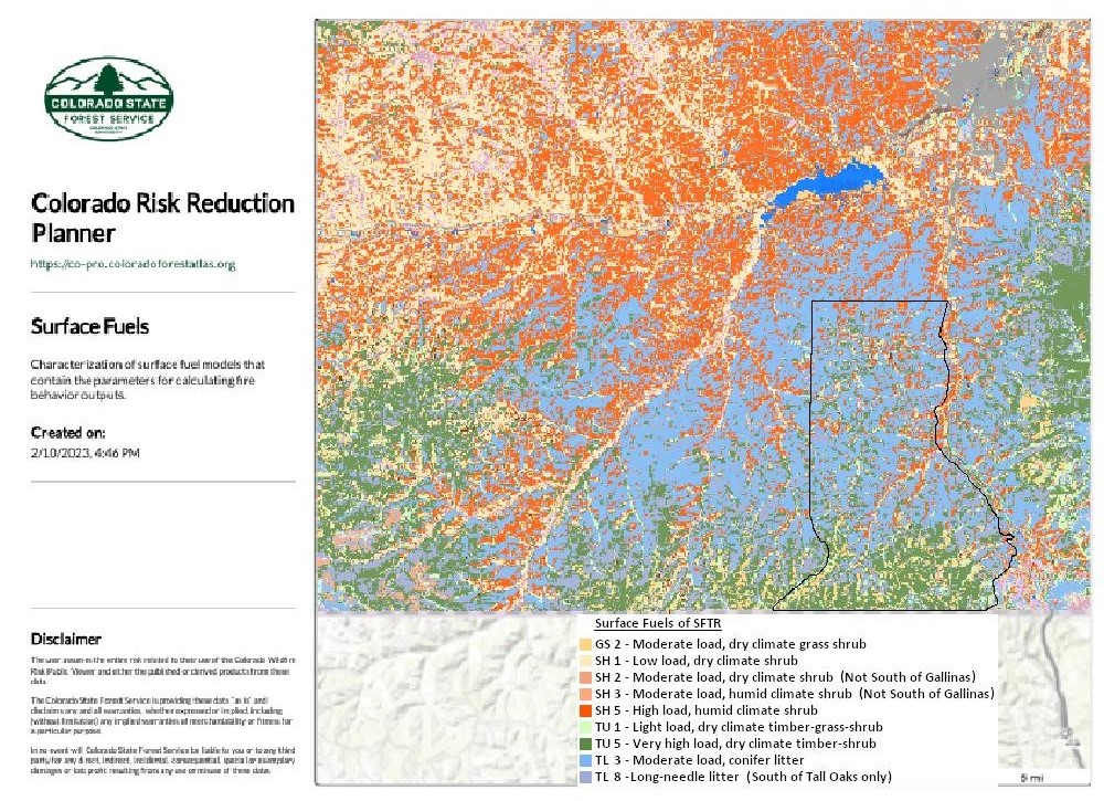
Appendix G: SFTR Surface Fuels
This “Surface Fuels” map illustrates that the northern two thirds of the SFTR is primarily covered with a moderate load of conifer litter with small patches of Low to High loads of dry and humid climate shrubbery. The predominate surface litter abruptly changes south of about 37 degrees, 1.5 minutes north, (elevations exceeding 7600 feet) roughly beginning at Tall Oaks Drive and the southern portions of Fox Trail, Timber Park Dr and Fisher Peak Parkway. The surfaces fuels in the southern third of the SFTR are primarily very high loads of dry climate timber and shrubs with patches of low to moderate loads of dry climate shrubbery, conifer and long-needle litter.
| SFTR CWPP | 38 | 4/23/2024 |
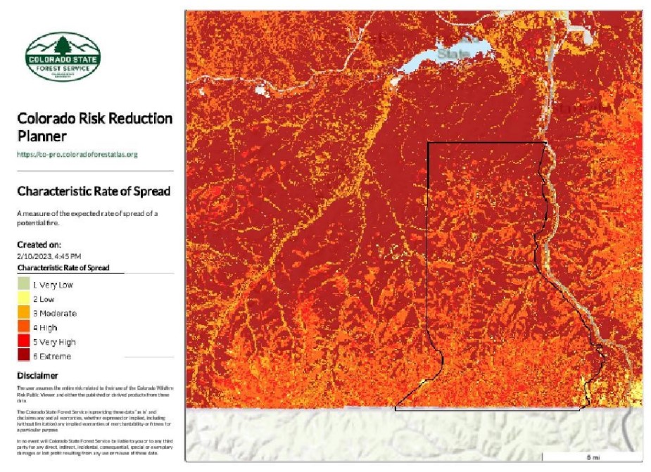
Appendix H: SFTR Rates of Spread
This “Rates of Spread” map illustrates that the northern two thirds of the SFTR has a higher rate of spread than the southern third of the ranch (elevations exceeding 7600 feet). The northern border of the ranch is rated “Extreme”. The rating in the center of the ranch varies from “Extreme” through “High”. The the highest rates of spread roughly correspond with canyon bottoms.
| SFTR CWPP | 39 | 4/23/2024 |
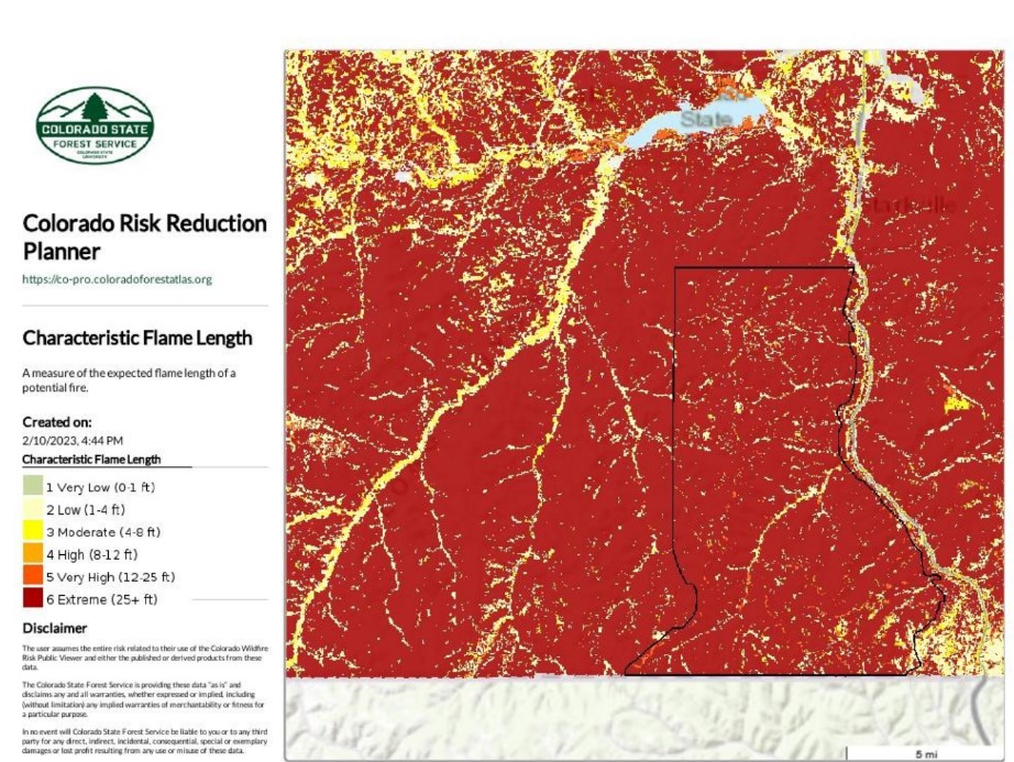
Appendix I: SFTR Flame Lengths
This “Flame Lengths” map illustrates that, with the exception of established
roadways, virtually the entire SFTR has a Flame Length rating of “Extreme – greater
than 25 feet.
| SFTR CWPP | 40 | 4/23/2024 |
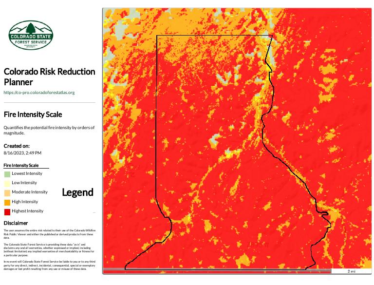
Appendix J: Colorado Forest Atlas fire behavior maps
The Colorado Forest Atlas is a web portal providing a suite of interactive mapping applications about Colorado’s forests. Within the Forest Atlas is the Colorado Wildfire Risk Planner, designed to support community wildfire protection planning needs. The Colorado Wildfire Risk Planner application was used to generate the Fire Intensity, Rate of Spread, Spotting and Building Damage Potential maps below.
“The following are indeed rather compelling maps regarding various components of risk. I feel that they illustrate the comprehensive nature of the wildfire risk at SFTR and likely continue to facilitate your mitigation momentum.” (Paul Branson - CSFS Forester)
The Fire Intensity Scale map illustrates that other than the most northern section of the SFTR, the majority of the ranch will experience a very high intensity fire behavior characterized by very large flames up to 150 feet in length, profuse short-range spotting, frequent long-range spotting and strong fire-induced winds.
Indirect attack will be marginally effective at the head of the fire. There is great potential for harm or damage to life and property.
| SFTR CWPP | 41 | 4/23/2024 |
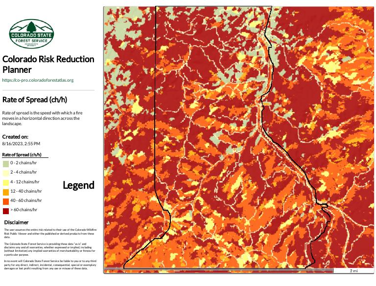
The Rate of Spread map illustrates that much of the northern section of the SFTR will experience a higher rate of fire spread that the southern end of the ranch. Rate of spread is the speed with which a fire moves in a horizontal direction across the landscape, usually expressed in chains per hour (ch/hr), approximately equivalent to feet per minute (ft/min). Most of the SFTR will experience a fire rate of spread of between 12 and 60 feet per minute or between 720 and 3,600 feet per hour (0.1 and 0.7 miles per hour).
| SFTR CWPP | 42 | 4/23/2024 |
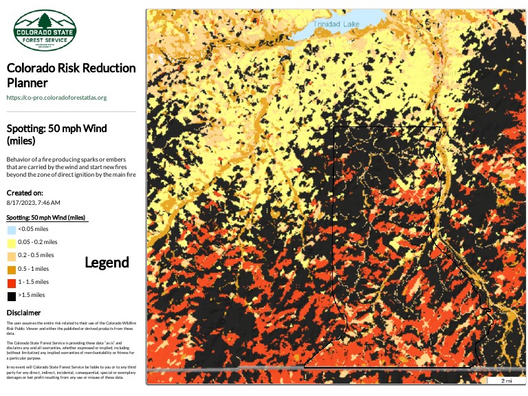
The Spotting 50 mph windSpotting 50 mph wind map illustrates that the majority of the SFTR is susceptible to fire produced by sparks of embers (starting new fires) that are carried by the wind from over a mile away.
| SFTR CWPP | 43 | 4/23/2024 |
The Building Damage Potential map estimates that the potential for building loss and is between High and Very High for over 90 percent of the buildings on the Santa Fe Trail Ranch.

| SFTR CWPP | 44 | 4/23/2024 |
Appendix K: Addresses on the Santa Fe Trail Ranch
In 2006, based on a comprehensive study that was done by an outside consultant who looked at SFTR from a fire safety perspective, it was recommended that the POA revise the road name and address system on the ranch. If the address that you current have is not 5 digits with the first 2 digits being 33, this address will be changed when you decide to build, get a septic permit, electricity or building permit. To obtain an official address, contact the POA Address Committee on the Santa Fe Trail Ranch website. Be aware that the Post Office often will not assign a mailbox at exit 6 until you can produce a C.O. (certificate of occupancy). Alternatively, a post office box may be rented at the post office.
The SFTR addressing scheme is based upon the road to which the primary driveway is connected. It is important that the address “road name” corresponds with the road names on the official ranch road map, small deviations can cause confusion.
Below is a SFTR Addressing Scheme chart that has a “Road Name” column listing the 64 unique road names on the ranch which are also listed on the SFTR Ranch Map found on the SFTR website.
Address numbers are assigned according to the following scheme. Every road has a defined “Road Entry” location. Address numbers are always five digits, the first two digits always being “33” (i.e. 33xxx Road Name). The last three digits (xxx) of the address is the distance in miles (to the hundredth of a mile) from the “Road “Entry” location. Even address numbers are on the right side of the road as they proceed to the end of the road and odd address numbers are on the left. As a result, address numbers increase from the “Road Entry” location to the end of a road.
In the case of cul-de-sacs, the “Road Entry” location is where the cul-de-sac begins. All addresses on a cul-de-sac are the distance in miles (to the hundredth of a mile) from the “Road Entry” location of the cul-de-sac to the primary driveway. For instance, the point of “Road Entry” location for Mountain Meadow Overlook is at Gallinas Pkwy and the “Road End” is a cul-de-sac. Thus, the address of lot D13 near the “Road Entry” location of Mountain Meadow Overlook is 33051 MOUNTAIN MEADOW OVERLOOK and the address of lot D6 near the “Road End” location is 33210 MOUNTAIN MEADOW OVERLOOK. The actual length of Mountain Meadow Overlook is 2.10 miles.
The “Road Entry” location of other roads is somewhat arbitrary. The designated “Road Entry” location for all 62 roads can be found in the SFTR Addressing Scheme chart below. The address at the “Road Entry” location of a road will always be 33000. The address at the “Road End” will correspond to the length of the road (to the hundredth of a mile). For instance, the “Road Entry” location for Alpine Meadows is at Timber Park Dr and the “Road End” location is at Fisher Peak Pkwy. Thus, the address of lot F11 near the “Road Entry” location of Alpine Meadows is 33009 ALPINE MEADOWS DR and the address of lot G11 near the “Road End” location is 33498 ALPINE MEADOWS DR. The actual length of Alpine Meadows is 5.20 miles.
| SFTR CWPP | 45 | 4/23/2024 |
|
ROAD NAME |
Road Type |
Road Entry |
Road End |
Miles |
|
ALPINE MEADOWS DR |
Connector |
Timber Park Dr |
Fisher Peak Pkwy |
5.2 |
|
ANTELOPE RUN |
Cul-de-sac |
Turkey Creek Ln |
Cul-de-sac @ Lot B64 |
0.4 |
|
ASPEN TR |
Cul-de-sac |
Alpine Meadows Dr |
Cul-de-sac @ Lot F3 |
0.5 |
|
BEAR PAW LN |
Cul-de-sac |
Mountain View |
Cul-de-sac @ Lot B43 |
0.2 |
|
BIG BEAR DR |
Cul-de-sac |
Coyote Track Tr |
Cul-de-sac @ Lot E37 |
0.1 |
|
BIG SPRINGS OVERLOOK |
Cul-de-sac |
Fox Trail |
Cul-de-sac @ Lot D67 |
0.5 |
|
BOBCAT CT |
Connector |
Mountain View |
Wildwood Ln |
0.4 |
|
CEDAR RIDGE LN |
Cul-de-sac |
Mountain View |
Cul-de-sac @ Lot B32 |
0.3 |
|
CEDAR WAY |
Cul-de-sac |
Vista West Dr |
Cul-de-sac @ Lot 51 |
0.3 |
|
CHIPMUNK DR |
Cul-de-sac |
Mountain View |
Cul-de-sac @ Lot B68 |
0.5 |
|
CONIFER DR |
Cul-de-sac |
Mountain View |
Cul-de-sac @ Lot B80 |
0.5 |
|
COTTONWOOD CANYON DR |
Connector / Cul-de-sac |
Fisher Peak Pkwy |
Cul-de-sac @ Lot B3 |
3.2 |
|
COYOTE TRACK TR |
Cul-de-sac |
Squirrel Ln |
Cul-de-sac @ Lot E37 |
0.9 |
|
CURRANT CT |
Cul-de-sac |
Mountain View |
Cul-de-sac @ Lot C2 |
0.2 |
|
DEER TRAIL LN |
Cul-de-sac |
Meadow Ridge Ln |
Cul-de-sac @ Lot B16 |
0.3 |
|
EAGLE NEST OVERLOOK |
Cul-de-sac |
Elk Ridge Trl |
Cul-de-sac @ Lot B60 |
0.4 |
|
ELK PARK RD |
Connector |
Cottonwood Canyon Dr |
Vista West Dr |
4.0 |
|
ELK RIDGE TRL |
Cul-de-sac |
Cottonwood Canyon Dr |
Cul-de-sac @ Lot B67 |
1.2 |
|
ENGLEMAN CT |
Cul-de-sac |
Gallinas Pkwy |
Cul-de-sac @ Lot D16 |
0.8 |
|
FAWN CT |
Cul-de-sac |
Trail Ridge |
Cul-de-sac @ Lot E7 |
0.3 |
|
FISHER PEAK PKWY |
Evacuation Rd |
Exit #6 Entry Bridge |
Lot J2 to Lot D56 |
8.5 |
|
FOX TRAIL |
Connector |
Gallinas Pkwy |
Timber Park Dr |
3.0 |
|
GALLINAS PKWY |
Connector / Cul-de-sac |
Fisher Peak Pkwy |
Cul-de-sac @ Lot E18 |
5.8 |
|
GREY FOX CT |
Cul-de-sac |
Squirrel Ln |
Cul-de-sac @ Lot E33 |
0.3 |
|
HIDDEN MEADOW LN |
Cul-de-sac |
Fox Trail |
Cul-de-sac @ Lot D75 |
1.0 |
|
HIDDENWOOD LN |
Cul-de-sac |
Cottonwood Canyon Dr |
Cul-de-sac @ Lot C52 |
0.5 |
|
JUNIPER OVERLOOK |
Cul-de-sac |
Alpine Meadows Dr |
Cul-de-sac @ Lot F13 |
0.2 |
|
LARIAT CT |
Cul-de-sac |
Timber Park Dr |
Cul-de-sac @ Lot D72 |
0.2 |
|
LITTLE BEAR DR |
Connector |
Fisher Peak Pkwy |
Vista West Dr |
2.9 |
|
LOCUST CT |
Cul-de-sac |
Timber Park Dr |
Cul-de-sac @ Lot D54 |
0.3 |
|
LODGEPOLE TRACE |
Cul-de-sac |
Alpine Meadows Dr |
Cul-de-sac @ Lot F25 |
0.9 |
|
MEADOW CT |
Cul-de-sac |
Bobcat Ct |
Cul-de-sac @ Lot C20 |
0.3 |
|
MEADOW RIDGE LN |
Cul-de-sac |
Mountain View |
Cul-de-sac @ Lot B8 |
1.1 |
| SFTR CWPP | 46 | 4/23/2024 |
|
ROAD NAME |
Road Type |
Road Entry |
Road End |
Miles |
|
MORA LN |
Cul-de-sac |
Cottonwood Canyon Dr |
Cul-de-sac @ Lot 76 |
0.1 |
|
MOUNTAIN MEADOW OVERLOOK |
Cul-de-sac |
Gallinas Pkwy |
Cul-de-sac @ Lot D6 |
2.1 |
|
MOUNTAIN VIEW |
Connector / Cul-de-sac |
Elk Park Rd & Cottonwood Canyon Dr & Tall Oaks |
Cul-de-sac @ Lot H2 |
7.1 |
|
OAK PARK DR |
Connector / Cul-de-sac |
Elk Park Rd |
Cul-de-sac @ Lot 1 |
2.3 |
|
OAK WAY |
Cul-de-sac |
Elk Park Rd |
Cul-de-sac @ Lot 67 |
0.3 |
|
OLD MISSION RIDGE |
Connector / Cul-de-sac |
Fisher Peak Pkwy |
Cul-de-sac @ Lot D27 |
1.6 |
|
PASS CREEK CT |
Cul-de-sac |
Oak Park Dr |
Cul-de-sac @ Lot 4 |
0.1 |
|
PINE NUT DR |
2 Cul-de-sacs |
Wildlife Run |
Lot 62 & Lot 65 |
0.4 |
|
PINION CT |
Cul-de-sac |
Oak Park Dr |
Cul-de-sac @ Lot 6 |
0.5 |
|
PONDEROSA RIDGE DR |
Cul-de-sac |
Elk Park Rd |
Cul-de-sac @ Lot 18 |
1.0 |
|
PORCUPINE CT |
Cul-de-sac |
Mountain View |
Cul-de-sac @ Lot D18 |
0.4 |
|
PTARMIGAN CT |
Cul-de-sac |
Mountain View |
Cul-de-sac @ Lot C6 |
0.2 |
|
PUMA CT |
Cul-de-sac |
Squirrel Ln |
Cul-de-sac @ Lot H13 |
0.1 |
|
RATON OVERLOOK |
Cul-de-sac |
Little Bear Dr |
Cul-de-sac @ Lot 7 |
0.3 |
|
SQUAW CREEK LN |
Cul-de-sac |
Meadow Ridge Ln |
Cul-de-sac @ Lot B13 |
0.3 |
|
SQUIRREL LN |
Cul-de-sac |
Gallinas Pkwy |
Cul-de-sac @ Lot H11 |
2.6 |
|
SUNSET DR |
Cul-de-sac |
Mountain View |
Cul-de-sac @ Lot B40 |
0.7 |
|
TALL OAKS DR |
Connector |
Gallinas Pkwy |
Mountain View |
1.2 |
|
TALL TIMBER TRACE |
Cul-de-sac |
Mountain View |
Cul-de-sac @ Lot C31 |
1.0 |
|
TIMBER PARK DR |
Connector |
Old Mission Ridge |
Gallinas Pkwy |
3.6 |
|
TIMBER RIDGE LN |
Cul-de-sac |
Mountain View |
Cul-de-sac @ Lot B27 |
1.0 |
|
TIMBER WOLF RUN |
Cul-de-sac |
Old Mission Ridge |
Cul-de-sac @ Lot D25 |
0.3 |
|
TRAIL RIDGE |
Cul-de-sac |
Gallinas Pkwy |
Cul-de-sac @ Lot E11 |
|
|
TURKEY CREEK LN |
Connector |
Fisher Peak Pkwy |
Cottonwood Canyon Dr |
3.9 |
|
VISTA WEST CT |
Cul-de-sac |
Vista West Dr |
Cul-de-sac @ Lot 48 |
0.1 |
|
VISTA WEST DR |
Connector / Cul-de-sacs |
Little Bear Dr & Elk Park Rd |
Lot 40 & Lot 56 |
3.4 |
|
WESTWOOD DR |
Cul-de-sac |
Mountain View |
Cul-de-sac @ Lot C51 |
0.8 |
|
WILD PLUM LN |
Cul-de-sac |
Mountain View |
Cul-de-sac @ Lot C8 |
0.3 |
|
WILDLIFE RUN |
Connector |
Vista West Dr |
Pine Nut Dr |
0.7 |
|
WILDWOOD LN |
2 Cul-de-sacs |
Bobcat Ct |
Lot C16 & Lot C19 |
0.3 |
|
YUCCA CT |
Cul-de-sac |
Alpine Meadows Dr |
Cul-de-sac @ Lot D37 |
0.2 |
| SFTR CWPP | 47 | 4/23/2024 |
Appendix L: References
Anderson, Hal E. 1982. Aids to determining Fuel Models for Estimating Fire Behavior. USDA Forest Service. General Technical Report INT-122, 22 p. Intermountain Forest and Range Experiment Station, Utah, 84401. Alternate link:
Aids to Determining Fuel Models
Andrews, Patricia; Bevins, Collin; and Seli, Robert. 2003. Behave Plus fire modeling system User’s Guide. USDA Forest Service. General Technical Report RMRS-GTR-106WWW. Rocky Mountain Research Station. Alrernate link:
Dennis F.C. 1999. Forest Home Fire Safety. No 6.304 Natural Resource Series.
Colorado State University Cooperative Extension. Alternate link:
Dennis F.C. 2002. Fire Wise Plant Materials. No 6.305 Natural Resource Series.
Colorado State. Alternate link:
Dennis F.C. 2005. Fuel break Guidelines for Forested Subdivisions & Communities. Colorado State Forest Service. Alternate Link:
Graham, Russell. 2003. Editor. Hayman Fire Case Study: Summary. USDA
Forest Service. General Technical Report RMRS-GTR-115. Rocky Mountain
Research Station. Alternate link:
USDA - Wildfire, Wildlands, and People: Understanding and Preparing for
Wildfire in the Wildland-Urban Interface. Alternate link:
USDA Wildfire, Wildlands, and People
SFTR Website Links:
SFTR Metropolitan District:
Santa Fe Trail Ranch Website:
https://santafetrailranch.com/
SFTR Ranch Map:
SFTR Firewise Information:
| SFTR CWPP | 48 | 4/23/2024 |
SFTR FHWM committee:
SFTR Preparedness committee:
SFTR Grazing committee:
Website Links:
Colorado State Forest Service – Local Website:
https://csfs.colostate.edu/la-veta/
Colorado State Forest Service – Forest Atlas:
https://coloradoforestatlas.org/
Colorado State Forest Service – Colorado Wildfire Risk Planner:
https://co-pro.coloradoforestatlas.org/#/
Colorado State Forest Service – Forest Action Plan:
https://csfs.colostate.edu/forest-action-plan/
Colorado State Forest Service – Fuel Break Guidelines:
https://static.colostate.edu/client-files/csfs/pdfs/fuelbreak_guidellines.pdf
CSFS Home Ignition Zone 2021:
https://csfs.colostate.edu/wp-content/uploads/2021/04/2021_CSFS_HIZGuide_Web.pdf
or:
CSFS Home Ignition Zone Checklist:
https://csfs.colostate.edu/wildfire-mitigation/home-ignition-zone-checklists/
CSFS Forest Action Plan:
https://csfs.colostate.edu/forest-action-plan/
USFS - Managing the Land > Wildland Fire
https://www.fs.usda.gov/managing-land/fire
USFS - When your community in on the fire line
https://www.fs.usda.gov/features/when-your-community-fire-line
National Fire Protection Association Website:
https://www.nfpa.org/Public-Education/Fire-causes-and-risks/Wildfire/Firewise-USA
Las Animas County Hazard Mitigation Plan:
https://www.jeo.com/sites/default/files/inline-files/01_Las%20Animas_Upfront.pdf
Las_Animas_County_CodeRED_website:
https://public.coderedweb.com/CNE/en-US/4E3D59D2F3E5
or:
| SFTR CWPP | 49 | 4/23/2024 |
Documents & Maps:
Vermejo Park & Wootton Ranch fuel break:
SFTR SW Fuelbreak Project:
SFTR Proposed fuel break map:
SFTR Mitigation Map:
SFTR Fire Control Features map – 2023:
SFTR Surface Fuels:
SFTR Rates of Spread:
SFTR Flame Lengths:
Spotting %0 mph wind map:
Building Damage Potential map:
| SFTR CWPP | 50 | 4/23/2024 |


